


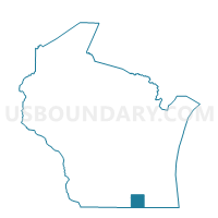
Delavan - C 3 Voting District, Walworth County, Wisconsin
About
Outline

Summary
| Unique Area Identifier | 697446 |
| Name | Delavan - C 3 Voting District |
| County | Walworth County |
| State | Wisconsin |
| Area (square miles) | 0.81 |
| Land Area (square miles) | 0.81 |
| Water Area (square miles) | 0.00 |
| % of Land Area | 100.00 |
| % of Water Area | 0.00 |
| Latitude of the Internal Point | 42.62449240 |
| Longtitude of the Internal Point | -88.65567440 |
Maps


Graphs
Select a template below for downloading or customizing gragh for Delavan - C 3 Voting District, Walworth County, Wisconsin


Neighbors
Neighoring Voting District (by Name) Neighboring Voting District on the Map
- DARIEN - T 3 Voting District, Walworth County, WI
- DARIEN - T 4 Voting District, Walworth County, WI
- Delavan - C 1 Voting District, Walworth County, WI
- Delavan - C 2 Voting District, Walworth County, WI
- Delavan - C 4 Voting District, Walworth County, WI
- Delavan - C 7 Voting District, Walworth County, WI
- Delavan - C 9 Voting District, Walworth County, WI
- DELAVAN - T 5 Voting District, Walworth County, WI
Top 10 Neighboring County Subdivision (by Population) Neighboring County Subdivision on the Map
- Delavan city, Walworth County, WI (8,463)
- Delavan town, Walworth County, WI (5,285)
- Darien town, Walworth County, WI (1,693)